Thursday, April 28, 2011

Wrightsville Beach, NC, 4/28/11

We left Bald Head Island and took the short cut to Wrightsville Beach.  We sailed up the Intracoastal Water Way.  That made our trip only about 25 nautical miles instead of 70 miles, due to the reefs that extend out 20 miles into the ocean.  There was only a one mile long narrow spot with very shallow waters on both sides that we had to slow down for.  We did not go aground!
The weather today is predicted to be severe with high winds, so we are staying in Wrightsville Beach for the day.  Tomorrow is supposed to be much nicer.  We plan to go to Cape Lookout tomorrow.  Winds are up to 23 knots right now.  Gusts are predicted to be up to 35 knots.


                                       At the dock at Wrightsville Beach.
   

Tuesday, April 26, 2011

Bald Head Island, NC, 4/26/11

The marina at Hilton Head was 15 miles from where the markers for the harbor entrance started.  There are a lot of reefs along the coast.  The water is only 50 to 70 feet deep along the coast, until you get close to the golf stream which is about 50 miles out.  We left Hilton Head, SC at about 0630 on the 23rd and arrived the same day in Charleston, SC at 2100.  We saw several bottle nose dolphins not too far from the boat.  The reefs ran out about 10 miles off shore and are marked with buoys.  We met our new crew member, Mike, in Charleston. We also met his twin brother and sister-in-law.  We went to their home, swam in a neighbors pool, walked the beach, played some cards and had a great time.  We stayed the night with them and left the next day at 1100 (Monday).  We arrived Tuesday at 1100 at Bald Head Island, NC.  We caught a King Mackerel that was about 40 pounds and 4 feet 6 inches long.  We have enough fish in the refrigerator for lots of dinners. 


                               Sunset at sea on our way to Charleston, SC.


          Container ship coming out of Charleston Harbor as we were entering.

                                                Erin hoola hooping

                            Where we spent the afternoon in Charleston


The crew in front and Mike's brother and sister-in-law behind us

                                                  The fort at Charleston


                                 This is where the fish get cleaned.


The King Mackerel we caught shortly after leaving Charleston.


                           Old baldy light house on Bald Head Island


Wednesday, April 20, 2011

St. Augustine, FL, 4/20/11

We left Port Canaveral on Monday morning and arrived at St. Augustine on Tuesday morning at about 9:00 AM.  It was high tide.  On the way up I caught a Spanish Mackerel.  We also say 3-5 bottle nose dolphin swimming at our bow and all around the boat for about 10 minutes.  They were having fun and we enjoyed seeing them up close.  One jumped about 3 feet into the air.  We also saw a big sea turtle on the way up.  The winds were only 6 to 10 knots out of the East.  We sailed about half way up.  The wind dropped to 5 knots, then we decided to motor and get to St. Augustine before low tide.  They have a 6 foot tide in St. Augustine right now.  We spent Tuesday and Wednesday in St. Augustine exploring the town and seeing many of the sites.  We also took a kayak tour on the river in town. Tomorrow morning we plan to go about 5 miles off shore, then head North to St. Simons Island in Georgia.  It should take us about 24 hours.

                             The girls planning Amber's baby gift registry.

                                               The Spanish mackerel
One of the buildings in St. Augustine
                            This shows the low tide on the river in St. Augustine
                               The fort in St. Augustine from the water. 
                                  Erin flirting with the town sheriff
                      This is what happened to me when I tried to break them up


Tuesday, April 12, 2011

Port Canaveral, FL 4-12-11

In Port Lucaya we rented a motor scooter and went to the National Park and hiked to see the caves, mangroves and beach.  It was all very nice.

We left Port Lucaya, Grand Bahama Island at about 9:00 AM on Monday and arrived in Port Canaveral at about noon on Tuesday.  We started out motoring with no wind, but after about 6 hours we had enough wind to sail.  We caught one Barracuda on the way to Florida.  When we got to the Gulf Stream, our speed over ground was between 1 and 3.5 knots more than our speed over water.  Winds were out of the South West so the chop in the stream was not bad at all.  The winds got up to 17 knots and with the Golf Steam pushing us, we were moving along at 9 knots at times.  The waves were only about 3 to 5 feet. We had a bird that was resting on the boat for about 45 minutes.  We also caught a barracuda on the way.

We left the boat for a few days to spend time with my wife in Florida.  We expect to be back on the boat heading North on Monday.
  
Erin in Ben's Cave at the National Park.  Note the bats on the ceiling about in the middle of the picture.

                              The beach at the National Park

At the Park Beach


                                        The barracuda we caught


               Sunset at sea on our trip to Florida


                                   A bird resting on the boat at sea

Saturday, April 9, 2011

Port Lucaya, Freeport, Grand Bahama Island, 4-9-11

We left Highbourne Cay for the North Side of one of the Berry Islands.  It took us about 12 hours to get there.  We got to where we wanted to anchor at about 7:00 PM, just before sunset.  We were the only boat anchored in the bay.  The next day we left for Nassau, passing between the yellow and white banks, where there is coral head.  We saw and had to avoid about a dozen coral heads.  This is not a trip to take on a rainy, overcast day or at night.  We spent the next day in Nassau, shopping downtown and at the straw market.  We also walked around the Atlantis Resort on Paradise Island.  We felt like we were back in civilization.  The grocery store shelves were full, unlike many of the other islands.  On the trip to Port Lucaya, we caught two barracuda.  One was eaten by another fish, probably a shark as I was reeling it in.  All that was left was the head when I got it to the boat.
                                    Sunrise at Highbourne Cay

An easy life stop sign on Highbourne Cay.

On a hike at Highbourne Cay

Hiking at Highbourne Cay

We followed the sign to see a natural spring.

                               The beach at Highbourne Cay

                                 Another beautiful sunset

                  Sharks where they feed them at the fish cleaning station

                                The beach at Highbourne Cay Marina

                  The harbor in Nassau can be a difficult place to anchor

                                     Erin at the Nassau straw market

                                             On Paradise Island
All that was left of the barracuda
One of the fish I caught


                          Another beautiful sunset in the Berry Islands

This is the first I have seen the Ocean so calm.

                 The ship used in the Pirates of the Caribbean Movie

                                The ship again, up close
                                      The ship again up close

Monday, April 4, 2011

Highbourne Cay, Bahamas, 4-4-11

Erin and I are in a marina at Highbourne Cay, in the Exhuma Island of the Bahamas.  We asked our third crew member to leave in Staniel Cay, (our stop of a few days ago) as we were having personallity clashes. 

The weather is great as usual.  80 during the day and about 70 at night.  The winds are almost always out of the East to South East and are pushing us along our desired route.  We had 18 to 22 knot winds today with 5 to 7 foot waves on our trip up from Wardwick Wells Cay.  We did some hiking in the Exhuma Land and Sea Park yesterday and this morning.  We have not been in a marina since we were in Rum Cay.  Today is a day to have our laundry done and catch up on some internet tasks.  The water here is crystal clear.  On our approach to Conception Island we could see the bottom at 100 foot depth.  We plan to leave for Nassua on Wednesday and go through the Bahama Bank.  That is a little scary, since there are coral heads in the bank and at times the water depth is only 6 foot or less.  We will be following a recommended route and keeping a watch.

We see flying fish about every 10 minutes on our open sea passages.  They are very interesting.  I think we see so many because they think the boat is a big fish that is going to attack them. 

                           At sunrise on our way to the Exhuma Islands.

                                             Erin at the helm at sea.
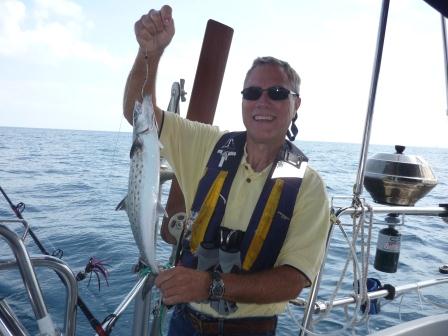
                        The dolphin I caught, I also caught a smaller one.
                                  On the hook at Conception Island.
                         Erin eating Mahi-mahi that we caught (she normally does not like fish).
                                    On the internet at Flying Fish Marina
                                             The beach at Rum Cay.
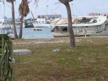
                                      The Grocery store on Rum Cay.
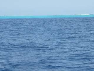
Were the water depth goes from 2000 feet to 50 feet the color changes.
                                  At anchor on Conception Island.
                                  On a hike at Wardwick Wells Cay.
Hiking at Wadwick Wells Cay.
                            The ocean side of Wardwick Wells Cay.
                              One of the beachs at Wardwick Wells Cay.